I found 446 results for Borghi

Costa de' Nobili

Costa de' Nobili is located on a hill surrounded by the sandy and clayey lands of the depressions of the Po and Olona rivers. In the early 13th century, Costa became the property of the Pietra family of Pavia. The castle complex, dating back to the 13th-14th centuries, consists of two buildings (one of which is the ancient Palace, now housing the Town Hall) connected by a central tower. On either side were two additional towers, now truncated. The central tower, 20 meters tall but reduced to a ruin, stood over the old entrance to the castle. On State Road No. 234, which leads from Pavia to Cremona, about 20 km from Pavia, a junction leads to Costa de’ Nobili, a small town in the Pavia area situated on some rises of sandy and clayey land that the Po and Olona rivers have deposited over millennia. In recent decades, many of these elevations have been leveled as they were used as sand quarries for road construction, flood defense embankments for the two rivers, and as building materials. As noted by Don Gianfranco Mascheroni in his book "Costa de’ Nobili Pietra and the Church of S. Maria Assunta" (Pavia, 1982), it was the Lombard kings, particularly Liutprand (8th century), who encouraged settlement in these wild and marshy lands, prone to frequent floods, linking them, through donations, to the Benedictine monasteries of Santa Cristina and Salvatore in Pavia. Among these lands was the location of Costa, originally named for its elevated position compared to the surrounding area.

Redavalle

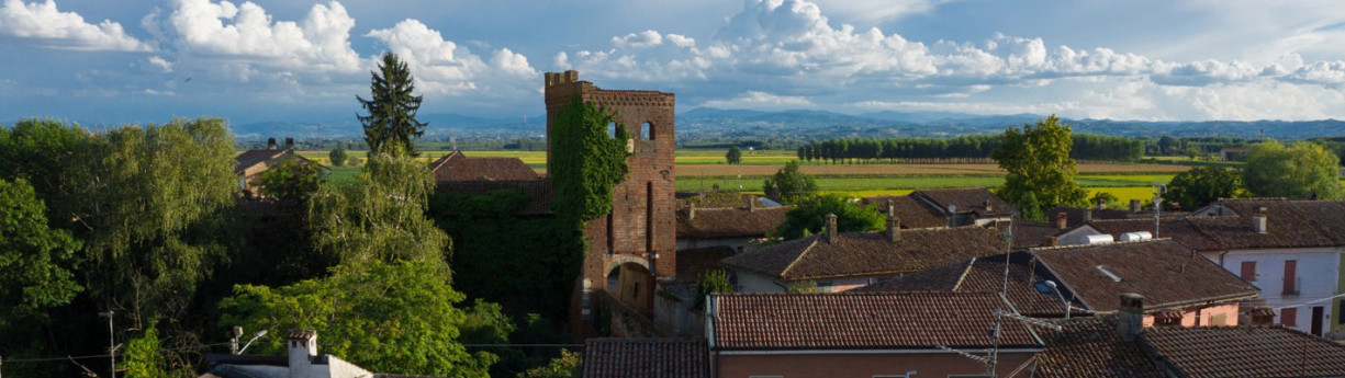
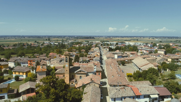
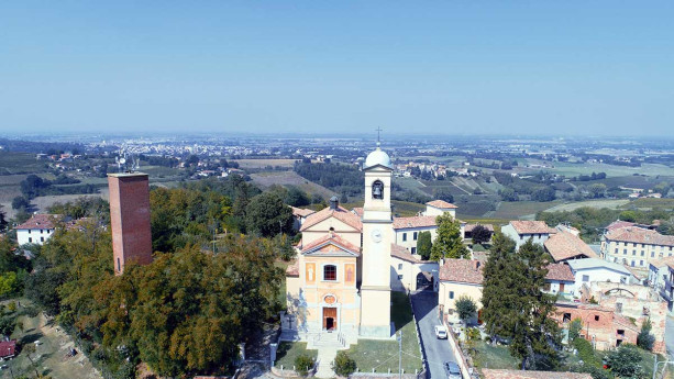
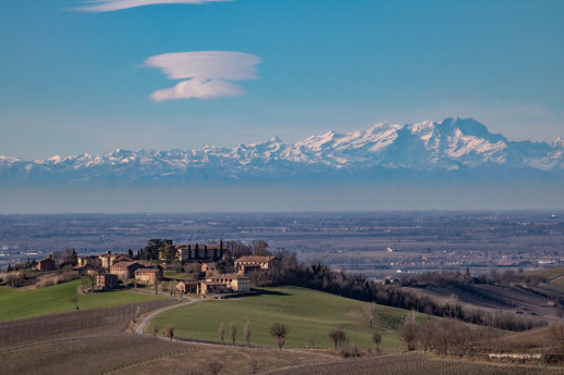
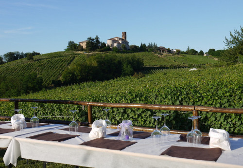
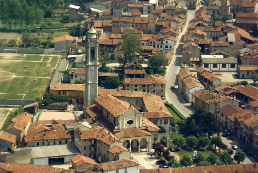
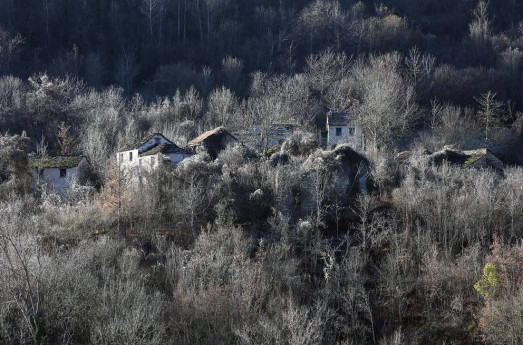
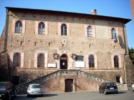
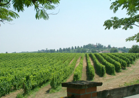
The current Redavalle is the heir of an older settlement, San Martino in Strada. In the area, there existed a Roman settlement mentioned in ancient itineraries as Cameliomagus or Comillomagus (forms resulting from the careless writing of a probable Camillomagus). The itinerary distances would suggest Broni as the location, but it is certain that numerous Roman artifacts have been found in Redavalle, which proves the Roman origin of San Martino in Strada, whether it corresponds to Camillomagus or not. Like many ancient centers that survived the barbarian invasions, it had its own parish, dependent on the diocese of Piacenza, whose name (San Martino in Strada) replaced the ancient name of the location. San Martino came under Pavia's dominion in 1164, when it was probably a dependency of Broni; it was, however, equipped with a castle, which was burned by the forces of the Lombard confederates during the wars against Frederick I Barbarossa. San Martino in Strada, located slightly to the east of Redavalle, never recovered from the disaster. It was then that Redavalle (so named in 1250), situated on the western edge of the San Martino municipality, began to grow in importance, eventually absorbing the entire population of the old center. Around 1560, the San Martino parish was abandoned, and the archpriest settled at the chapel of San Rocco in Redavalle (which took the name of San Rocco and San Martino). Redavalle was part of the Broni fief, which from the 13th century belonged to the Beccaria family and, from 1536 until the end of feudalism (1797), to the Arrigoni family of Milan. As mentioned, Redavalle stood near the western boundary of the municipality, so much so that part of the town extended into the adjacent municipality of Santa Giuletta; this anomaly was resolved in 1866 with the transfer of a section of Santa Giuletta’s territory to Redavalle (called the Rile fraction). Redavalle: a small village at the foot of the hills of Oltrepò Pavese, just a couple of minutes by car along the Via Emilia, but a place like any other only on road maps. This spot, halfway between the cities of Casteggio and Broni, now houses a population of just over 1,000 souls: it once represented the most important center on the route between Iria (Voghera) and Placentia (Piacenza). Its origins date back to the pre-Roman period; its founders and first inhabitants were the Ligurian and Celtic populations who contested dominion over the territory before the Roman conquest at the end of the 3rd century BC: Cameliomagus was its name, as reported on the Tabula Peuntiger, a kind of road map depicting Roman itineraries, major centers, and post stations. Among these, at 17 Roman miles from Iria and 25 from Placentia, the settlement of Cameliomagus is listed, stretching its boundaries up to the present-day villages of Manzo (Santa Giuletta) and Ca' del Piano (Cigognola). The center is to be located at the foot of the hills, in the territory of Redavalle and Cassino Po, scattered with inns, stables for changing horses, taverns, shops, and patrician villas, of which unfortunately no large remains remain: some inscriptions, many coins, urns, lamps, and funeral furnishings, mostly found in the Gragnolate necropolis, the Vacca d'oro and Bruciati estates, and during 19th-century excavations at the demolished Bornaghi kiln. Present in several lower hill areas of Redavalle, along which the Postumia road ran, are fragments, tiles, bricks, and other evidence of the Roman presence, which was constant and prosperous until the decline of the Empire. Due to its strategic position, ancient Cameliomagus suffered, starting at the end of the 4th century AD, a progressive impoverishment due to the barbarian invasions and the economic and political instability of those centuries. The slow Christianization of the first millennium brought significant historical, religious, and architectural changes to ancient Redavalle, but only a few remains are left, the first of which is the ruined pillar at the entrance to the town coming from Broni, near the junction with the road leading to Pietra de' Giorgi. This pillar, commissioned by Archpriest Primo Andrea Sterpi in 1724, was erected to commemorate the Pieve of San Martino in Strada, probably built in the 9th-10th century AD, which for several centuries gathered in its divine worship the parishes and populations of neighboring towns, including Cigognola, Pietra de' Giorgi, Barbianello, Mornico Losana, and Santa Giuletta. It was an important Pieve, with structures to accommodate travelers and pilgrims on the Roman Way, whose power, however, was weakened over the centuries by plagues and the neglect of its rulers, leading to the abandonment and decay of the church, replaced for services by a chapel in the town center dedicated to San Rocco, later expanded in the early 18th century by architect Veneroni into the current structure, masterfully restored in the last decade of the last century. The rule of the Franks, followed by the local feudal dominations and the power of the individual municipalities, marked a dark period in Redavalle’s history: it is unfortunately remembered for the burning of the town's castle in 1164 by the people of Piacenza and Cremona, fighting against the city of Pavia, allied with Frederick Barbarossa, an event engraved in popular tradition and depicted on the town’s coat of arms. In the following centuries, after the Renaissance dominations of the Visconti-Sforza, came that of the Spanish and, from 1713, the Austrians. The village, which gradually formed around the aforementioned chapel, was embellished in the 17th century by the construction of two chapels at the entrance to the town, now restored and dedicated to the Madonna and the memory of the Fallen. In 1743, with the Treaty of Worms, the territory of Redavalle, along with all of Oltrepò Pavese, passed under Savoy rule, later becoming part of the province of Pavia in 1861. Source: Comune di Redavalle PHOTO:  Portale www.visitoltrepo.com

Castana

P A town in the eastern Oltrepò, whose name originates from the chestnut groves that likely characterized the surrounding hills. Known in ancient times as castrum castanae (literally, the fortified center of chestnuts), Castana was already mentioned in Roman times as ad Castanem in the regional map compiled by the 19th-century historian Severino Capsoni. Located 25 kilometers from the provincial capital, Castana is a small rural town nestled between the Val Versa and the Valle Scuropasso, at just under 300 meters above sea level. In the center of the town are the remains of a medieval castle, built on a hill that dominates the valley, making Castana an important strategic hub. The castle was probably built by the Pavia monks of San Bartolomeo in Strada. The village experienced alternating fortunes over the centuries. In the 1200s, when Castana was just a fortified settlement surrounded by a few houses with straw roofs (as evidenced by a historical document from that period), it was devastated by fighting between the Cremonese and Piacentini forces, who were in conflict with the Marquis of Monferrato, who had sought refuge behind its walls. During the fighting, the castle was set on fire. In 1531, Castana was part of the Broni fiefdom, ruled by the Beccaria family. Upon their extinction, it passed to the Borromeo family and later to the Arrigoni and Pallavicino families. The transition from a medieval village to a renowned wine-producing center was not immediate, but it is certain that today Castana is much better known for its fine wines than for its, albeit interesting, historical and artistic aspects. From its vineyards come excellent red wines such as Barbera, Bonarda, Buttafuoco, Rosso Oltrepò, and Sangue di Giuda. THINGS TO SEE A destination for those seeking good wine and refreshment, especially in the summer, Castana boasts, in addition to the ancient fortress (which was rebuilt in the 1700s and later transformed into a noble palace by the then owners, the Pallavicini Trivulzio family), a parish church. Built in the 19th century, the Church of St. Andrew, now with three naves (the original design had just one), houses valuable paintings and recalls a curious tilted bell tower, which was later demolished for safety reasons and replaced with a "straight" one. SOURCE: UNIONE DI COMUNI LOMBARDA PRIMA COLLINA  

Zenevredo

The municipality of Zenevredo is located in the hills of the Oltrepò Pavese, not far from the plains, on the right bank of the Versa stream. The village of Zenevredo is characterized by a predominantly hilly landscape, typical of the Lower Po Valley. The toponym, as Cenevretum, first appears in the list of lands of the Pavia countryside from 1250, as part of the Oltrepò. Zenevredo appears in the list of declarations of the hearth tax in the Principality of Pavia for the year 1537, as part of the rural Congregation of Oltrepò and Siccomario. The prefect of the Marengo department, according to the law of the 28th day of the rainy year VIII (February 1800), appoints the mayors and their assistants of the municipality of Zenevredo with a decree of 23 Fruttidoro year IX (September 1801). Zenevredo is included in the Marengo department and the Voghera district (Campana decree 1801). In the first pratile year X (May 1802), the prefect of the Marengo department decrees the appointment of 10 municipal councilors, who are to remain in office for three years (Campana decree 1802). In 1805, due to the restructuring of the Ligurian-Piedmontese administration desired by Napoleon Bonaparte, Zenevredo, by decree of June 13, 1805, was merged into the department of Genoa, Voghera district (decree 1805, ASC Casei Gerola). In 1859, with a population of 372 inhabitants, Zenevredo became part of the province of Pavia and was included in the IX district of Montù Beccaria, Voghera district (decree 1859). Upon the formation of the Kingdom of Italy in 1861, the municipality had a resident population of 385 inhabitants (Census 1861). According to the 1865 municipal organization law, the municipality was governed by a mayor, a council, and a board. Following the reform of the municipal organization in 1946, the municipality of Zenevredo continued to be governed by a mayor, a council, and a board. Source: https://www.visitoltrepo.com

Oliva Gessi

O Oliva Gessi is a small municipality with 162 inhabitants, located in the hills of the Oltrepò Pavese, between Casteggio and Montalto Pavese, near the Rile San Zeno and Verzate streams. The second part of its name comes from the gypsum deposits, historically exploited and situated in the locality of Gessi. Oliva Gessi is home to the M. Defilippi Theatre, which, with its 100 seats in relation to its 175 inhabitants, can be considered one of the largest in Europe. The local parish church is dedicated to Saint Martin of Tours. Inside, there is a statue of Luigi Versiglia, a Salesian bishop and martyr who was killed in China in 1930 and canonized in 2000 by Pope John Paul II. In front of the church entrance, the "Path of the Martyrs" (Salita dei Martiri) was erected in honor of Saint Luigi Versiglia and Saint Callistus Caravario. In the center of Oliva, there stands a castle that the Isimbardi family transformed into a noble residence in the first half of the 19th century. THE CASTLE The castle has a quadrilateral layout, with a central courtyard and a large carriage entrance on the eastern side. A high wall encloses the castle on three sides, and the existence of a tower is hypothesized due to a protrusion on the northern side. These structures have undergone several modifications over time, eventually forming the quadrilateral complex that still stands at the highest point of the small village. Today, the castle is privately owned.Since 1999, the Antica Corte has hosted opera and symphonic concerts as part of the Ultrapadum Festival. BIRTHPLACE OF SAINT LUIGI VERSIGLIA Personal belongings, memorabilia from his life in China, photographs, documents, and other artifacts are carefully preserved for both religious pilgrims and general visitors. SOURCE: www.borghiecastelli.eu PHOTO: Piermaria Greppi Scotti  

Santa Giuletta

A Santa Giuletta Originally inhabited by Ligurian and Gallic tribes, later home to a Roman settlement, Santa Giuletta boasts an ancient winemaking tradition. Documents dating back to around the year 1000 describe it as one of the most vineyard-rich hill territories in Northern Italy. In 1879, researchers from the Botanical Garden of Pavia discovered one of the earliest outbreaks of downy mildew (Plasmopara viticola), a fungus of American origin that nearly wiped out Italy’s vineyards. Once part of the Feud of Broni (13th century), the area later came under the control of different noble families: the Beccarla in the 15th century, the Trotti and the Isimbardi in the 18th century. During the Kingdom of Savoy, it served as a district capital and, in more recent history, played a significant role in the Italian Resistance during World War II. What to See Santa Giuletta is home to several noteworthy landmarks: The Castle, located in the hamlet of the same name, sits atop a hill. Of the original 12th-century structure, only the underground cellars remain—once used as grim prisons. Today, the complex appears as an 18th-century neoclassical villa, extensively restored and currently undergoing further renovation under new ownership. The Castle Parish Church, also closed for restoration, was built in the 13th century and dedicated to Saint Julitta, a Greek martyr. It contains beautiful paintings in the Caravaggesque style. The Two Towers, one known as Sarolli-Griziotti, embody both romantic and Renaissance elements. A scenic road winds up from the town center on Via Emilia to the Castello hamlet, offering breathtaking views of the vast Po Valley on one side and the rolling hills and layered peaks of the Apennines on the other. Along this route, travelers pass historic vineyards and stunning organic wineries. Near the Castello hamlet, the Isimbardi-Vismara Castle and Parish Church stand out, with olive trees and thriving caper bushes growing on their southern slopes. The Doll and Toy Museum Once, the dolls of Santa Giuletta were famous worldwide. In the 1950s, newspapers ran extensive articles about this small town, entirely dedicated to designing and producing dolls with all their accessories. Nearly every household was involved in this craft, and around twenty factories employed about a thousand workers, not to mention the widespread network of subcontractors and home-based artisans across the region. It was a true local industry. Initially, the dolls were made of papier-mâché through a highly elaborate process and were primarily decorative pieces for newlyweds’ living rooms and sofas. Later, plastic replaced traditional materials, leading to innovations such as walking and talking dolls, followed by plush toys and other playthings. Today, this once-thriving industry has all but disappeared. To preserve this rich heritage, the Municipality of Santa Giuletta has curated a collection of dolls, toys, photographs, molds, tools, labels, and catalogs from the 1930s to the 1980s, now housed in a museum. The museum’s purpose extends beyond tourism to include cultural, historical, and educational initiatives. Over the years, workshops focused on artistic craftsmanship have been held, including one dedicated to doll-making. A new municipal library has been established alongside the museum, designed for exhibitions and research on dolls and local history. A highlight of the museum is its artisan workshop, where traditional papier-mâché dolls, modeled after pre-WWII designs, will be recreated. SOURCE: Municipality of Santa Giuletta

San Ponzo Semola

A stop along the Voghera-Varzi railway, which was active between 1931 and 1966 and has now been converted into a cycling and pedestrian path

Portalbera

Portalbera is a municipality in the Oltrepò Pavese, located at the point where the Po River receives the waters of the Versa stream. The earliest documented history of the village is marked by disputes over its possession between the Diocese of Piacenza and the Diocese of Pavia. As early as the 13th century, Portalbera had a ferry and a small river port, with docking facilities for river navigation. Two large poplar trees marked the port’s location— in the local dialect, the poplar is called "albra", which gave rise to the name Porto Albra (Port of the Poplars), later evolving into Portalbera. The presence of travelers is evidenced by the construction of a Pilgrims' Hospice in Portalbera—the first encountered along the Via Romea from France—founded in 1114 by Bishop Guido of Pavia, with the support of cardinals, bishops, and abbots from both Italy and France. Along with the pilgrims, merchants also traveled through the area: trade routes from nearby Piacenza to Genoa necessarily passed through Portalbera, highlighting its strategic importance. Until about seventy years ago, the Po River flowed right next to the village. In 1916, Portalbera still had its historic pontoon bridge over the river. However, following a flood, the bridge was swept away by the rising waters. It was later rebuilt further downstream, in Spessa Po, where the remains of the old pontoon bridge had settled. Portalbera's economy was historically based on river transport and trade. However, after World War II, the economic landscape changed significantly, as the town could no longer rely on its port and bridge, and the Portalberesi had never been significantly involved in agriculture. The bell tower of the Church of Maria Vergine Assunta, an 18th-century building, stands at 51 meters, making it the tallest in the Diocese of Tortona. Source: Municipality of Portalbera

Rovaiolo Vecchio

A ghost town in the Oltrepò Pavese, on the border with the province of Piacenza

Villanterio

Villanterio is located in the eastern Basso Pavese, spanning both banks of the southern Lambro river, on the border with the province of Lodi.   The origins of Villanterio date back to Roman times, but it was during the Middle Ages that the village gained strategic importance. Dominated for centuries by various noble families, including the Visconti and Sforza, it still preserves traces of its past in its historic buildings. Among them, the Castle of Villanterio stands out, once a defensive fortress and now transformed into a private residence. Palazzo Rizzi was built between 1540 and 1547 by Giovanni Angelo Rizzi, chamber secretary of Duke Francesco II Sforza of Milan and chancellor of the Milanese secret council. In 1538, he acquired the feudal jurisdiction of Villanterio from Emperor Charles V's imperial chamber. At that time, the old castle was divided among several noble families, so Rizzi bought all the small portions of the castle from the various nobles. The main floor of the palace was internally divided into a large hall and five consecutive rooms. All the rooms were covered by lunette vaults adorned with frescoes, with an extraordinary pictorial cycle that also extended along the walls. The last of the Rizzi family left the palace to Count Galeazzo Attendolo Bolognini (1667). From that moment, the palace began to decline and was downgraded to a residence for tenant farmers. In 1876, the Municipality of Villanterio purchased it from the Bolognini family to use it as an elementary school, municipal offices, and accommodation for the town clerk. (Source: FAI - Fondo Ambiente Italiano).

Cervesina

Cervesina is located in the plains of Oltrepò Pavese, on the right bank of the Po River, near the confluence of the Staffora stream, just a few kilometers from Voghera. The Parish Church of San Lorenzo is one of the main places of worship in the town, housing precious works of art. The Castle of San Gaudenzio is an imposing structure that captivates visitors with its history and evocative appearance. Cervesina and San Gaudenzio were once two separate municipalities; during the Middle Ages, San Gaudenzio was more important, especially from a religious perspective, as it was the seat of a pleban church overseeing several surrounding villages. The Castle of San Gaudenzio, a historical oasis of Lombard heritage, has preserved the charm of the place and the sweetness of life through time. Its history is intertwined with the Visconti family and the fate of Pavia: it is a complex dating back to the 1400s that belonged to numerous noble families (the Beccaria, Taverna, and Trotti families) who passed down its grandeur. Originally a place for hospitality and rest, hosting balls, banquets, and celebrations, the castle has naturally retained this role as a splendid hotel full of charm. Inside the castle, you will find beautiful red and black marble fireplaces, furniture, portraits, and decorations dating from the 1500s to the 1700s. Adjacent to the castle is the ancient church dedicated to San Gaudenzio. What was once a place of delights for a few privileged individuals has today become a pleasant gathering spot for anyone looking to enjoy the subtle charm of the Oltrepò Pavese countryside, just a short distance from the bustling industrial cities. The idea of giving a new purpose and social utility to the remains of this glorious castle led to the creation of the Ristorante San Gaudenzio within the ancient fortress. Continuing this tradition, the castle offers a series of rooms and apartments, elegantly furnished and equipped with modern amenities. The sobriety, elegance, and harmony of the castle are reflected in the adjacent park-garden, which complements the 15th-century structure. The recently created garden has significant features of 17th-century design, representing a period of not only ideological transition but also stylistic change. The garden, once strictly geometric and Renaissance in style, is gradually transforming into a park, offering a sense of liberation and vitality. Tall trees, flowering shrubs, and fruit-bearing plants create the floral composition of this space. Conifers and broadleaf trees alternate, enhancing the visual appeal of the area. Statues, a pergola, and a temple contribute to the artistic elements of the park. Along the entrance to the castle and beside the old moat, imaginative flowerbeds offer an example of "Ars Topiaria."
San Gaudenzio

Bosnasco

B osnasco is a municipality with approximately 650 inhabitants in the province of Pavia. It is located on the hills of Oltrepò Pavese, at the edge of the plain, on the border with the province of Piacenza. The area has been known since the 12th century, when it was contested between Piacenza and Pavia, which had recently gained control over Oltrepò Pavese through an imperial diploma. By arbitration, the area was assigned to Pavia. Under the rule of the Beccaria family, it became part of the Arena Po estate, belonging to the branch of the family that took its name from Arena. This estate, in contrast with the Visconti family at the beginning of the 15th century, saw its main center confiscated but was able to retain Bosnasco until its extinction in 1695. Bosnasco was inherited by the Busca family and later passed on to the Bellisomi and Corsi di Nizza families, shortly before the end of feudalism in 1797. Viticulture, wine production, cellars, and the main food and wine resources are the primary industries of the municipality of Bosnasco. SOURCE: MUNICIPALITY OF BOSNASCOPHOTO: TENUTA SCARPA COLOMBI