I found 164 results for trekking

Lago d'Iseo- Best trails

Discover Lake Iseo's best trails with the new trekking guide!

Experiencing the mountains in Valtellina

Arrampicata. Rafting. Lunghi trekking o passeggiate rilassanti. Il benessere delle terme. Scopri il lato Active & Green della Valtellina
Trekking e relax in Valtellina

ANA REFUGE

Trekking at Tignale
http://www.gardalombardia.it/ImmaginiProdottiP/rifugio-ana_18_420x1000.jpg

Infopoint Sulzano

  The Infopoint Sulzano is located on Piazza 28 Maggio near the pier from which boats leave to Monte Isola and other places on Lake Iseo.   The office offers citizens, tourists and visitors the tourist information service with particular reference to: – information, distribution of material relating to  Sulzano, Monte Isola and other lakeside locations;– information on accommodation and catering facilities;– distribution of material relating to excursions, cycle and trekking routes in the area;– information on events, public transport and roads. The multilingual staff in the office is available to users to meet all their needs with cordiality and professionalism.
Infopoint Sulzano

Infopoint of Monte Isola

  Monte Isola Tourist Office is located on the lakefront in Peschiera Maraglio, about 100 meters after the pier 1, from which the boats from and to Sulzano arrive and depart.   The office offers to citizens, tourists and visitors the tourist information service with particular reference to: – information, distribution of material relating to the Monte Isola area and other lakeside locations;– information on accommodation and catering facilities;– distribution of material relating to excursions, cycling and trekking routes in the area;– information on events, transport and viability. The office’s multilingual staff is available to satisfy all users’ needs with cordiality and professionalism.  
Infopoint Monte Isola

Infopoint Intercomunale Marone Città dell'Olio

The Marone Tourist Office is located in the civic hall of the ex library, the adress is via Roma, 42 in the historic center of the town.   The office offers citizens, tourists and visitors the tourist information service with particular reference to:– information, distribution of material relating to the territory of Marone and other lakeside locations;– information on accommodation and catering facilities;– distribution of material relating to excursions, cycle and trekking routes in the area;– information on events, transport and roads.The bilingual office staff is available to users to meet all their needs with friendliness and professionalism.
Infopoint Marone

Infopoint Pisogne

Pisogne Tourist Office is located in Piazza Umberto I, in the historic centre of the town.   The office offers citizens and visitors touristic information services with particular reference to: information, distribution of material relating to Pisogne and other lakeside locations; information on accommodation and catering facilities; distribution of material relating to excursions, cycling and trekking routes in the area; information on events, transport, and viability. The office’s multilingual staff is available to satisfy all users’ needs with cordiality and professionalism
Infopoint Pisogne

The shelters

Valmalenco is the most extended of Valtellina lateral valleys : changeableheights ranging from 500 and 4000 metres, a peak sequence nearlyconstantly winding above 3000 m that culminates in 4050 m of PizzoBernina, alpine horizons incorporating all vegetative strips, numberlessstriking corners with small lakes, streams, waterfalls. In addition to allthis, you will be able to find a suitable road network, efficient public services,equipped and comfortable downstream and upstream accommodation facilitiesas well as a mixture of well indicated pathways...Trekking paradise is just here.

Waterfalls | Varese Convention & Visitors Bureau

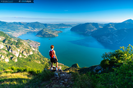
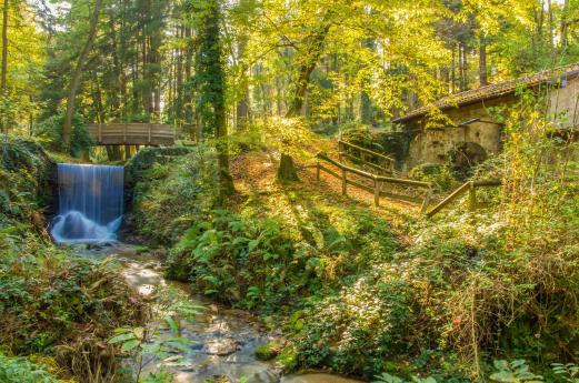
Among the green of our province there are several marvelous waterfalls. Ferrera waterfall - Situated in the municipality of Ferrera the waterfall is also known by local people as Fermona. It is located about 30 meters just below the village where the Margorabbia river flows out from the caves of the Cunardo ravine to reach Valtravaglia. At the bottom of the waterfall there's a small lake where water is crystal clear and completely surrounded by nature. - How to get there: follow directions from the centre of Ferrera, walking for a short distance the bicycle path that comes from Rancio Valcuvia. Discover trekking and bike paths around here.   Dog of all sizes allowed in leasch in compliance with the hygiene and public safety rules*     @nix1380 e @smillaegrace Cittiglio waterfalls - There are 3 waterfalls in Cittiglio, reachable by a path that starts from the old part of the village. They are formed from S. Giulio stream and situated at an altitude between 324 and 474 meters high, in a natural environment of an amazing beauty. - How to get there: follow directions from Pianella street in Cittiglio. Discover trekking and bike paths around here.  Dog of all sizes allowed in leasch in compliance with the hygiene and public safety rules*    @chiaraviaggiante e @matiskia Froda waterfall - In Nasca, part of Castelveccana municipality, is situated one of the most beautiful waterfalls of the province, hidden in the nature and so considered an amazing place. The itinerary to get there takes about half an hour in the nature. The waterfall is about 100 mt high and collects water that flow down from Cuvignone mountain. - How to get there: passing through Veccana, turning to Nasca and following the road S. Antonio where can find the directions. Discover trekking and bike paths around here.  Dog of all sizes allowed in leasch in compliance with the hygiene and public safety rules*    @nix1380 e @chiaraviaggiante Roggiano waterfall - In Roggiano Valtravaglia, just few steps after the tiny centre of the village, at the wooden bridge, a small waterfall hides itself in the green. Slow down and take your time if you're passing by. - How to get there: SS394; on the road that goes from Germignaga to Mesenzana you'll find a detour for Roggiano Valtravaglia; pass through the village taking the street to Brissago Valtravaglia Discover trekking and bike paths around here.  Dog of all sizes allowed in leasch in compliance with the hygiene and public safety rules*    @saradeluigi Plan your stay and your experience in the land of the lakes. Cover photo: @nix1380 * Information by the Local Municipality. For any other question please check the guidelines from the Municipalities
Cascate Varese

TIGNALE ROUTE

Trekking at Tignale
http://www.gardalombardia.it/ImmaginiProdottiP/cammino-tignale_112_420x1000.jpg

Val Viola

From the panoramic views of Lake Val Viola to outdoor activities in Alta Valtellina.
(Ph: I Mille)

Infopoint Sale Marasino

The Infopoint of Sale Marasino is located in via Roma, in the centre of the village next to the pier from which the boats to Monte Isola leave. The office offers citizens, tourists and visitors the tourist information and ticketing service with particular reference to: – Information, distribution of material relating to  Sale Marasino, Monte Isola and other lakeside locations;– Information on accommodation facilities and restaurants;– Distribution of material relating to excursions, cycle and trekking routes in the area;– Information on events, public transport and roads;– Ticketing service for Navigazione Lago d’Iseo. The multilingual staff in the office is available to users to meet all their needs with cordiality and professionalism.
Infopoint Sale Marasino